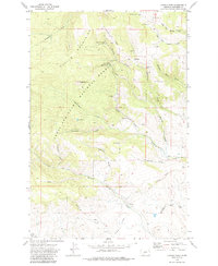
1972 Map of Castle Town
USGS Topo · Published 1986About this map
The Castle Mountains define the high country of this central Montana landscape, where the legacies of late 19th-century silver mining remain etched across the terrain. Established in the silver boom era, Castle Town is situated among the headwaters of Castle Creek and Alabaugh Creek, flanked by the Castle Cem and the extensive workings of the Cumberland Mines. The map documents a dense network of extraction sites scattered across Yankee Jim Ridge and the surrounding slopes, including the Judge Mine, Iron Chief Mine, and the Belle of the Castle Mine.
Find a feature on this map
40 named features on this map. Tap any name to fly to it.
Don’t see what you’re looking for? This feature index may not catch every label — zoom into the map to look around manually.
Map Details
Editions of this 1972 Castle Town Map
2 editions found
Other maps of this area

1886 · Little Belt Mts.
USGS Topo · 1:250,000

1894 · Little Belt Mts.
USGS Topo · 1:250,000

1897 · Little Belt Mts.
USGS Topo · 1:250,000

1898 · Little Belt Mts.
USGS Topo · 1:250,000

1902 · Little Belt Mts.
USGS Topo · 1:250,000

1948 · White Sulphur Springs
USGS Topo · 1:250,000

1951 · Hamen
USGS Topo · 1:24,000
1951 · Ringling
USGS Topo · 1:24,000

1951 · Rimrock Divide
USGS Topo · 1:24,000

1958 · White Sulphur Springs
USGS Topo · 1:250,000