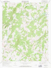
1971 Map of Castleton
USGS Topo · Published 1972About this map
The Hazel River and Thornton River define the winding geography of this section of the Rappahannock and Culpeper county border. In the early 1970s, this area remained largely rural, characterized by small communities like Castleton and Eggbornsville connected by narrow roads and river crossings. The map reveals a deeply religious local landscape, documented by a series of country churches including Gourdvine Ch, Beulah Ch, and New Salem Ch, which often served as the social anchors for these dispersed settlements. To the east, Monumental Mills stands along the river, hinting at the historical water-powered industry of the region, while the Hazel Landing Strip provides evidence of more modern local transportation. The terrain is dominated by significant peaks such as Castleton Mtn and Scott Mountain, which shaped the placement of farms and cemeteries like those found near Eldorada and Cordova.
Find a feature on this map
36 named features on this map. Tap any name to fly to it.
Don’t see what you’re looking for? This feature index may not catch every label — zoom into the map to look around manually.
Map Details
Editions of this 1971 Castleton Map
2 editions found
Other maps of this area

1887 · Spottsylvania
USGS Topo · 1:125,000

1892 · Spottsylvania
USGS Topo · 1:125,000

1892 · Gordonsville
USGS Topo · 1:125,000

1893 · Luray
USGS Topo · 1:125,000

1894 · Warrenton
USGS Topo · 1:125,000

1894 · Warrenton
USGS Topo · 1:62,500

1905 · Luray
USGS Topo · 1:125,000

1927 · Remington
USGS Topo · 1:48,000

1930 · Warrenton
USGS Topo · 1:62,500

1943 · Culpeper
USGS Topo · 1:24,000