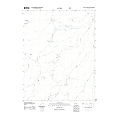
2011 Map of Casto Reservoir
USGS Topo · Published 2011About this map
Casto Reservoir and the nearby Big Creek Reservoir anchor this high-altitude landscape in Mesa County, where water management defines the remote terrain. The presence of Big Creek Ranch and Black Camp reflects a history of seasonal grazing and forestry operations that have long shaped the high plateaus and creek valleys of western Colorado. The map documents an intricate network of drainage systems, including Gill Creek, Smith Creek, and the many forks of Bear Creek, which cut through prominent landforms like Leonards Ridge and Smith Point. Topographical features such as Hungry Gulch and Dead Horse Pasture provide vivid clues to the early ranching and pioneer heritage of the area. Connectivity is maintained by the winding Divide Rd, which links isolated recreation sites like the Divide Forks Campground to the broader watershed of Big Dominguez Creek.
Find a feature on this map
33 named features on this map. Tap any name to fly to it.
Don’t see what you’re looking for? This feature index may not catch every label — zoom into the map to look around manually.
Map Details
Editions of this 2011 Casto Reservoir Map
This is the sole edition of this map. No revisions or reprints were ever made.
Other maps of this area

1949 · Calamity Mesa
USGS Topo · 1:24,000

1950 · Calamity Mesa
USGS Topo · 1:24,000

1950 · Pine Mountain
USGS Topo · 1:24,000

1956 · Moab
USGS Topo · 1:250,000

1959 · Moab
USGS Topo · 1:250,000

1960 · Moab
USGS Topo · 1:250,000
1960 · Gateway
USGS Topo · 1:62,500
1960 · Pine Mountain
USGS Topo · 1:24,000
1960 · Calamity Mesa
USGS Topo · 1:24,000

1962 · Moab
USGS Topo · 1:250,000