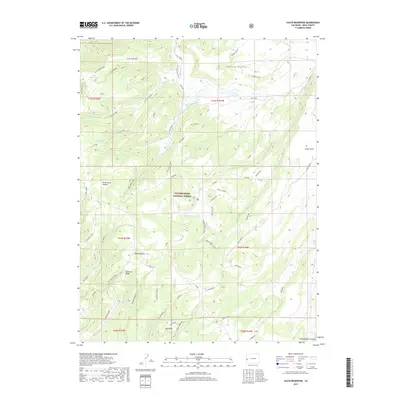
2019 Map of Casto Reservoir
USGS Topo · Published 2019About this map
Uncompahgre National Forest encompasses the high-country terrain of the Uncompahgre Plateau, where a network of seasonal streams and historic cattle-rearing infrastructure defines the landscape. The northern portion of the map is marked by significant water sources including Little Bear Lake and the Casto Reservoir, which support the high-altitude Big Creek Ranch. This area reflects the grazing history of Mesa County, with named landmarks such as Dead Horse Pasture and Leonards Ridge indicating the long-standing use of these benchlands. Navigational routes are deeply tied to the geography, from the Gill Creek Trailhead in the north to the Ute Creek Cutoff and Smith Point trails that navigate the plateau's rugged breaks and drainages like Big Dominguez Cr and Cow Creek.
Find a feature on this map
77 named features on this map. Tap any name to fly to it.
Don’t see what you’re looking for? This feature index may not catch every label — zoom into the map to look around manually.
Map Details
Editions of this 2019 Casto Reservoir Map
This is the sole edition of this map. No revisions or reprints were ever made.
Other maps of this area

1949 · Calamity Mesa
USGS Topo · 1:24,000

1950 · Calamity Mesa
USGS Topo · 1:24,000

1950 · Pine Mountain
USGS Topo · 1:24,000

1956 · Moab
USGS Topo · 1:250,000

1959 · Moab
USGS Topo · 1:250,000

1960 · Moab
USGS Topo · 1:250,000
1960 · Gateway
USGS Topo · 1:62,500
1960 · Pine Mountain
USGS Topo · 1:24,000
1960 · Calamity Mesa
USGS Topo · 1:24,000

1962 · Moab
USGS Topo · 1:250,000