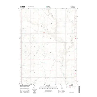
2017 Map of Castro Table
USGS Topo · Published 2017About this map
Castro Table and a series of high plateaus dominate this Owyhee County landscape, where the drainage patterns of Deep Creek and Nickel Creek have carved out distinct geographic features like Nickel Creek Pocket. The high desert terrain is punctuated by family and descriptive landmarks, such as Boni Table, June Grass Table, and Ben Mills Flat, reflecting the ranching heritage of the region. A sparse network of water sources including Swisher Spring and Bower Reservoir provide essential hydration in this arid environment. The presence of Grasshopper Rd and labels like Star Ranch Table suggest the long-standing agricultural and grazing use of the land. These landforms, including Bull Gulch and Big Point, illustrate the complex topography that historically challenged and guided movement through the Idaho backcountry.
Find a feature on this map
29 named features on this map. Tap any name to fly to it.
Don’t see what you’re looking for? This feature index may not catch every label — zoom into the map to look around manually.
Map Details
Editions of this 2017 Castro Table Map
This is the sole edition of this map. No revisions or reprints were ever made.
Other maps of this area

1955 · Jordan Valley
USGS Topo · 1:250,000

1957 · Jordan Valley
USGS Topo · 1:250,000

1958 · Jordan Valley
USGS Topo · 1:250,000

1973 · Red Basin
USGS Topo · 1:24,000
1973 · Wagon Box Basin
USGS Topo · 1:24,000

1973 · Smith Creek
USGS Topo · 1:24,000

1973 · Castro Table
USGS Topo · 1:24,000

1973 · Pleasant Valley
USGS Topo · 1:24,000
1973 · Dickshooter Reservoir
USGS Topo · 1:24,000

1973 · Brace Flat
USGS Topo · 1:24,000