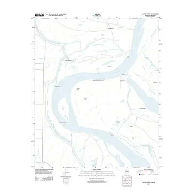
2012 Map of Catfish Point
USGS Topo · Published 2012About this map
The Mississippi River carves a massive, serpentine path through this 2012 survey, defining the border between Mississippi and Arkansas. The landscape is dominated by river dynamics, featuring the prominent Caulk Cut-off and a series of active and relic channels like Catfish Chute, Outer Chute, and Hobson Chute. Low-lying wetlands and backwaters such as Zellner Brake and Whitehill Lake sit behind the engineered Mississippi River Levee.
Find a feature on this map
44 named features on this map. Tap any name to fly to it.
Don’t see what you’re looking for? This feature index may not catch every label — zoom into the map to look around manually.
Map Details
Editions of this 2012 Catfish Point Map
This is the sole edition of this map. No revisions or reprints were ever made.
Other maps of this area

1933 · Lamont
USGS Topo · 1:62,500

1935 · Red Fork
USGS Topo · 1:62,500

1936 · McGehee
USGS Topo · 1:62,500

1937 · McGehee
USGS Topo · 1:62,500

1939 · Big Island
USGS Topo · 1:62,500

1939 · Lamont
USGS Topo · 1:62,500

1953 · Greenwood
USGS Topo · 1:250,000

1955 · McGehee
USGS Topo · 1:62,500

1956 · Greenwood
USGS Topo · 1:250,000
1969 · Kelso
USGS Topo · 1:24,000