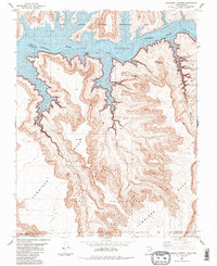
1985 Map of Cathedral Canyon
USGS Topo · Published 1985About this map
Lake Powell dominates the northern reaches of this landscape, its waters filling the depths of Glen Canyon after the completion of the Glen Canyon Dam. The 1985 topography illustrates the flooded canyon system where the Colorado River once flowed freely, now branching into intricate side-canyons like Little Arch Canyon and Cathedral Canyon. South of the high-water line, the massive uplift of Cummings Mesa rises sharply, its dissected plateaus part of the Navajo Indian Reservation. This intersection of federal recreation land and tribal territory is defined by distinctive geologic markers such as Cathedral Butte and natural spans like Carrot Top Arch and Keyhole Arch. The map details the drainage patterns of Sheep Mountain Canyon and Wetherill Canyon, providing a precise record of the shoreline and high desert terrain during the mid-1980s.
Find a feature on this map
17 named features on this map. Tap any name to fly to it.
Don’t see what you’re looking for? This feature index may not catch every label — zoom into the map to look around manually.
Map Details
Editions of this 1985 Cathedral Canyon Map
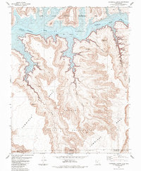
2 editions found
Other maps of this area

1883 · Marsh Pass
USGS Topo · 1:250,000

1886 · Escalante
USGS Topo · 1:250,000

1886 · Henry Mountains
USGS Topo · 1:250,000

1886 · Echo Cliffs
USGS Topo · 1:250,000

1891 · Echo Cliffs
USGS Topo · 1:250,000

1892 · Marsh Pass
USGS Topo · 1:250,000

1892 · Henry Mountains
USGS Topo · 1:250,000

1953 · Cummings Mesa
USGS Topo · 1:62,500

1953 · Navajo Mountain
USGS Topo · 1:62,500

1954 · Navajo Creek
USGS Topo · 1:62,500