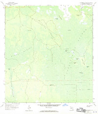
1958 Map of Catherine Island
USGS Topo · Published 1970About this map
Catherine Island and its surrounding wetlands define this sub-tropical landscape in Collier County, Florida, during the mid-twentieth century. The terrain is characterized by broad strands—linear swamp forests—including the Stumpy Strand, Lucky Lake Strand, and the expansive Fakahatchee Strand. Human presence in this environment is sparse but significant, marked by the Pennington Post Camp and evidence of much earlier inhabitants at the Indian Mound and Indian Mounds near Wilson Lake.
Find a feature on this map
23 named features on this map. Tap any name to fly to it.
Don’t see what you’re looking for? This feature index may not catch every label — zoom into the map to look around manually.
Map Details
Editions of this 1958 Catherine Island Map
3 editions found
Other maps of this area

1956 · West Palm Beach
USGS Topo · 1:250,000

1957 · West Palm Beach
USGS Topo · 1:250,000

1958 · West Palm Beach
USGS Topo · 1:250,000

1958 · Corkscrew SE
USGS Topo · 1:24,000

1958 · Catherine Island
USGS Topo · 1:24,000

1958 · Sunniland
USGS Topo · 1:24,000

1958 · Belle Meade NE
USGS Topo · 1:24,000

1958 · Immokalee SW
USGS Topo · 1:24,000

1958 · Belle Meade SE
USGS Topo · 1:24,000

1959 · Miles City
USGS Topo · 1:24,000