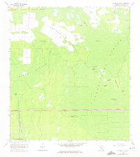
1958 Map of Catherine Island
USGS Topo · Published 1974About this map
Catherine Island and the surrounding cypress wetlands of Collier County are documented here during a period of transition in the mid-20th century. The northern portion of the map is defined by large, rectangular land clearings on the island itself, contrasting sharply with the natural hydrology of the Fakahatchee Strand and Stumpy Strand. A critical infrastructure development, the Everglades Parkway (Alligator Alley), cuts a straight path across the southern landscape, marking the increasing accessibility of the Florida interior. Cultural history is present in the form of ancient Indian Mounds and the Pennington Post Camp, which provide evidence of both prehistoric and modern human activity within the swamp. The network of scattered hammocks and water bodies, such as Curry Lake and Flinthead Lake, illustrates the complex drainage patterns of the Lucky Lake Strand before later developments altered the regional environment.
Find a feature on this map
23 named features on this map. Tap any name to fly to it.
Don’t see what you’re looking for? This feature index may not catch every label — zoom into the map to look around manually.
Map Details
Editions of this 1958 Catherine Island Map
3 editions found
Other maps of this area

1956 · West Palm Beach
USGS Topo · 1:250,000

1957 · West Palm Beach
USGS Topo · 1:250,000

1958 · West Palm Beach
USGS Topo · 1:250,000

1958 · Corkscrew SE
USGS Topo · 1:24,000

1958 · Catherine Island
USGS Topo · 1:24,000

1958 · Sunniland
USGS Topo · 1:24,000

1958 · Belle Meade NE
USGS Topo · 1:24,000

1958 · Immokalee SW
USGS Topo · 1:24,000

1958 · Belle Meade SE
USGS Topo · 1:24,000

1959 · Miles City
USGS Topo · 1:24,000