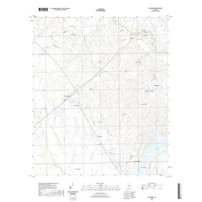
2020 Map of Catherine
USGS Topo · Published 2020About this map
Prairie Bluff stands at the southeastern edge of this landscape, overlooking a sharp bend in the Alabama River where the William 'Bill' Dannelly Reservoir now gathers. This 2020 map documents a region characterized by dispersed settlements like Catherine, Alberta, and Rehoboth, connected by a network of rural routes such as Chitlin Switch Rd and Boiling Springs Rd. The terrain is defined by its deep genealogical footprint, evidenced by over a dozen burial sites including the Henry Young Family Cem, Boiling Spring Cem, and the Shell Creek Cem. Numerous waterways, including Chilatchee Creek and Shell Creek, carve through the rolling elevations of Wilcox County, reaching toward the river bottomlands. The map provides a contemporary view of these established communities and their longstanding landmarks near the Dallas and Wilcox county line.
Find a feature on this map
58 named features on this map. Tap any name to fly to it.
Don’t see what you’re looking for? This feature index may not catch every label — zoom into the map to look around manually.
Map Details
Editions of this 2020 Catherine Map
This is the sole edition of this map. No revisions or reprints were ever made.
Other maps of this area

1953 · Montgomery
USGS Topo · 1:250,000

1956 · Montgomery
USGS Topo · 1:250,000

1957 · Montgomery
USGS Topo · 1:250,000

1968 · Thomaston East
USGS Topo · 1:24,000

1968 · Safford
USGS Topo · 1:24,000

1968 · Central Mills
USGS Topo · 1:24,000

1974 · Crumptonia
USGS Topo · 1:24,000

1974 · Catherine
USGS Topo · 1:24,000
1974 · Lee Long Bridge
USGS Topo · 1:24,000
1974 · Camden North
USGS Topo · 1:24,000