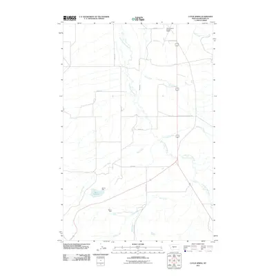
2011 Map of Catlin Spring
USGS Topo · Published 2011About this map
The South Fork Smith River carves a central path through this Montana landscape, where cattle ranching and water management define the rural character of Meagher County. Water rights and irrigation infrastructure are prominent across the terrain, evidenced by features such as Wertz Reservoir and the Sterret Dam near Hussey Creek, alongside Mayns Dam to the south. The eastern edge of the map transitions into the Lewis and Clark National Frst, marking a shift from open valley floor to protected highlands. Local transportation and connectivity are anchored by the White Sulphur Springs Airport in the north, while a network of named rural routes like Sixteenmile Rd and Rostad Rd link the scattered homesteads and pastures of the high plains.
Find a feature on this map
22 named features on this map. Tap any name to fly to it.
Don’t see what you’re looking for? This feature index may not catch every label — zoom into the map to look around manually.
Map Details
Editions of this 2011 Catlin Spring Map
This is the sole edition of this map. No revisions or reprints were ever made.
Other maps of this area

1886 · Fort Logan
USGS Topo · 1:250,000

1886 · Little Belt Mts.
USGS Topo · 1:250,000

1894 · Little Belt Mts.
USGS Topo · 1:250,000

1897 · Little Belt Mts.
USGS Topo · 1:250,000

1898 · Little Belt Mts.
USGS Topo · 1:250,000

1902 · Little Belt Mts.
USGS Topo · 1:250,000

1948 · White Sulphur Springs
USGS Topo · 1:250,000
1951 · Ringling
USGS Topo · 1:24,000
1951 · Black Butte Mountain
USGS Topo · 1:24,000

1958 · White Sulphur Springs
USGS Topo · 1:250,000