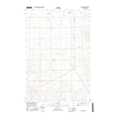
2017 Map of Catlin Spring
USGS Topo · Published 2017About this map
S Fork Smith River serves as the central drainage for this high-altitude Meagher County ranching and aviation landscape. The northern edge is dominated by the White Sulphur Springs Airport, while the remainder of the territory is defined by a network of drainage basins including Potter Cr, Fords Cr, and Cottonwood Cr. The named namesake Catlin Spring feeds into the local creek system, illustrating the vital role of water resources in this dry mountain environment. Local infrastructure is marked by several significant roads such as Sixteen Mile Rd and Battle Creek Rd, which navigate the township and range boundaries. In the south, the Wertz Reservoir and Prairie Cr indicate the careful management of runoff from the surrounding slopes. The map provides a clear look at the Public Land Survey System (PLSS) grid, showing how property and roads like Birky Rd align with historic section lines.
Find a feature on this map
25 named features on this map. Tap any name to fly to it.
Don’t see what you’re looking for? This feature index may not catch every label — zoom into the map to look around manually.
Map Details
Editions of this 2017 Catlin Spring Map
This is the sole edition of this map. No revisions or reprints were ever made.
Other maps of this area

1886 · Fort Logan
USGS Topo · 1:250,000

1886 · Little Belt Mts.
USGS Topo · 1:250,000

1894 · Little Belt Mts.
USGS Topo · 1:250,000

1897 · Little Belt Mts.
USGS Topo · 1:250,000

1898 · Little Belt Mts.
USGS Topo · 1:250,000

1902 · Little Belt Mts.
USGS Topo · 1:250,000

1948 · White Sulphur Springs
USGS Topo · 1:250,000
1951 · Ringling
USGS Topo · 1:24,000
1951 · Black Butte Mountain
USGS Topo · 1:24,000

1958 · White Sulphur Springs
USGS Topo · 1:250,000