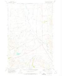
1971 Map of Catlin Spring
USGS Topo · Published 1975About this map
The White Sulphur Springs and Yellowstone Park Railway anchors this 1970s landscape, tracing a path through the valley of the South Fork Smith River. This corridor reflects the vital rail-and-ranching economy of Meagher County, where water resources were carefully managed for the high-plains environment. Significant water features such as the Wertz Reservoir and numerous named springs like Catlin Spring underscore the importance of irrigation and livestock watering in this region.
Find a feature on this map
12 named features on this map. Tap any name to fly to it.
Don’t see what you’re looking for? This feature index may not catch every label — zoom into the map to look around manually.
Map Details
Editions of this 1971 Catlin Spring Map
This is the sole edition of this map. No revisions or reprints were ever made.
Other maps of this area

1886 · Fort Logan
USGS Topo · 1:250,000

1886 · Little Belt Mts.
USGS Topo · 1:250,000

1894 · Little Belt Mts.
USGS Topo · 1:250,000

1897 · Little Belt Mts.
USGS Topo · 1:250,000

1898 · Little Belt Mts.
USGS Topo · 1:250,000

1902 · Little Belt Mts.
USGS Topo · 1:250,000

1948 · White Sulphur Springs
USGS Topo · 1:250,000
1951 · Ringling
USGS Topo · 1:24,000
1951 · Black Butte Mountain
USGS Topo · 1:24,000

1958 · White Sulphur Springs
USGS Topo · 1:250,000