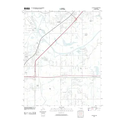
2010 Map of Catoosa
USGS Topo · Published 2010About this map
The Port of Catoosa serves as a major industrial hub along the Verdigris River, anchoring a landscape where river navigation meets complex rail and highway infrastructure. This 2010 survey details the transition from the concentrated industrial activity at the port to the residential and rural patterns of Verdigris and Fair Oaks. Significant family history markers are scattered throughout the quadrangle, including the Wofford Cemetery near Rascal Flat and the Timber Ridge Cemetery to the southeast.
Find a feature on this map
46 named features on this map. Tap any name to fly to it.
Don’t see what you’re looking for? This feature index may not catch every label — zoom into the map to look around manually.
Map Details
Editions of this 2010 Catoosa Map
This is the sole edition of this map. No revisions or reprints were ever made.
Other maps of this area

1901 · Claremore
USGS Topo · 1:125,000

1914 · Claremore
USGS Topo · 1:125,000

1916 · Claremore
USGS Topo · 1:125,000

1954 · Tulsa
USGS Topo · 1:250,000

1955 · Mingo
USGS Topo · 1:24,000

1955 · Broken Arrow
USGS Topo · 1:24,000

1956 · Collinsville
USGS Topo · 1:24,000

1958 · Tulsa
USGS Topo · 1:250,000

1963 · Tulsa
USGS Topo · 1:250,000
1963 · Oneta
USGS Topo · 1:24,000