
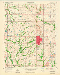
1955 Map of Broken Arrow
USGS Topo · Published 1956About this map
Broken Arrow stands as a developing hub at the intersection of the Missouri Kansas Texas railroad and several primary thoroughfares like Main Street and Broadway. The mid-century landscape is defined by its transition from agricultural and extraction activities to suburban expansion, evidenced by the numerous Oil Wells peppered throughout the Boles and Lynn Lane areas. To the southeast, the industrial presence of the Lone Star Strip Mine near the Tulsa Co Wagoner Co line contrasts with the civic development seen in the central district. Local aviation is represented by the Eightyfirst Street Landing Field, while community landmarks like the Drive-in Theater and Floral Haven Memorial Gardens indicate the growing infrastructure of the Tulsa metropolitan fringe. The survey also captures smaller outlying settlements such as Alsuma and Union, along with rural schools including St Anne Sch and South Side Sch.
Find a feature on this map
34 named features on this map. Tap any name to fly to it.
Don’t see what you’re looking for? This feature index may not catch every label — zoom into the map to look around manually.
Map Details
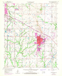
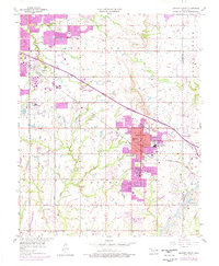
Editions of this 1955 Broken Arrow Map
5 editions found

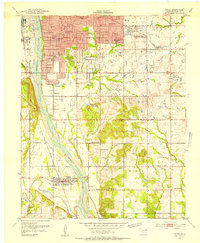
Other maps of this area

1896 · Okmulgee
USGS Topo · 1:125,000

1900 · Okmulgee
USGS Topo · 1:125,000

1901 · Claremore
USGS Topo · 1:125,000

1914 · Claremore
USGS Topo · 1:125,000

1916 · Claremore
USGS Topo · 1:125,000

1946 · Fort Smith
USGS Topo · 1:250,000
1952 · Jenks
USGS Topo · 1:24,000

1954 · Tulsa
USGS Topo · 1:250,000

1954 · Tulsa
USGS Topo · 1:24,000

1955 · Mingo
USGS Topo · 1:24,000