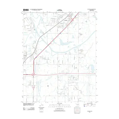
2012 Map of Catoosa
USGS Topo · Published 2012About this map
The Verdigris River serves as the central geographic spine of this Rogers and Tulsa County landscape, as documented in 2012. The town of Catoosa occupies the western bank, where complex highway infrastructure like the East Tulsa Interchange meets established neighborhoods. Moving east across the river, the settlement patterns transition from the more densely packed streets of Verdigris to the broader agricultural plots and residential clusters of Fair Oaks.
Find a feature on this map
149 named features on this map. Tap any name to fly to it.
Don’t see what you’re looking for? This feature index may not catch every label — zoom into the map to look around manually.
Map Details
Editions of this 2012 Catoosa Map
This is the sole edition of this map. No revisions or reprints were ever made.
Other maps of this area

1901 · Claremore
USGS Topo · 1:125,000

1914 · Claremore
USGS Topo · 1:125,000

1916 · Claremore
USGS Topo · 1:125,000

1954 · Tulsa
USGS Topo · 1:250,000

1955 · Mingo
USGS Topo · 1:24,000

1955 · Broken Arrow
USGS Topo · 1:24,000

1956 · Collinsville
USGS Topo · 1:24,000

1958 · Tulsa
USGS Topo · 1:250,000

1963 · Tulsa
USGS Topo · 1:250,000
1963 · Oneta
USGS Topo · 1:24,000