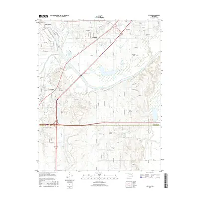
2016 Map of Catoosa
USGS Topo · Published 2016About this map
The Verdigris River snakes through the center of this landscape, anchoring a region where suburban growth from Owasso and Catoosa meets the river's historical floodplain. The map captures a transition in the Oklahoma countryside, showing established settlements like Verdigris and Fair Oaks alongside newer developments. For genealogists and local historians, several small burial grounds are documented, including Marshall Cem, River Hill Cem, and Crutchfield Cem, which offer physical markers of the area's earlier rural community. Transportation networks are prominent, with the Creek Tpke and Old US Hwy 66 cutting across the terrain. Notable local landmarks like the Sam Riggs Airpark and named water bodies such as Yonkapin Lake and Silver Lake provide specific points of interest within the broader river valley geography.
Find a feature on this map
120 named features on this map. Tap any name to fly to it.
Don’t see what you’re looking for? This feature index may not catch every label — zoom into the map to look around manually.
Map Details
Editions of this 2016 Catoosa Map
This is the sole edition of this map. No revisions or reprints were ever made.
Other maps of this area

1901 · Claremore
USGS Topo · 1:125,000

1914 · Claremore
USGS Topo · 1:125,000

1916 · Claremore
USGS Topo · 1:125,000

1954 · Tulsa
USGS Topo · 1:250,000

1955 · Mingo
USGS Topo · 1:24,000

1955 · Broken Arrow
USGS Topo · 1:24,000

1956 · Collinsville
USGS Topo · 1:24,000

1958 · Tulsa
USGS Topo · 1:250,000

1963 · Tulsa
USGS Topo · 1:250,000
1963 · Oneta
USGS Topo · 1:24,000