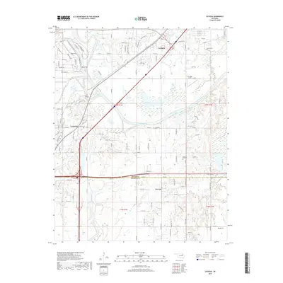
2019 Map of Catoosa
USGS Topo · Published 2019About this map
Catoosa sits at the convergence of vital Oklahoma waterways and transport corridors in this 2019 survey. The Verdigris River and Bird Creek dominate the central landscape, meeting near the settlement of Rascal Flat. This area illustrates the transition from the river bottomlands of Big Bottom to the growing residential footprints of Verdigris and Fair Oaks. Family history researchers will find several well-marked burial sites across the terrain, including River Hill Cem, Marshall Cem, and Timber Ridge Cem. The map provides a precise look at the modern road network, including Verdigris Pkwy and Fort Gibson RD, which weave around established natural features like Big Lake and Silver Lake. The boundary between Rogers Co and Wagoner Co bisects the lower portion of the sheet, marking a significant jurisdictional line through the developing suburbs east of the Tulsa metropolitan core.
Find a feature on this map
116 named features on this map. Tap any name to fly to it.
Don’t see what you’re looking for? This feature index may not catch every label — zoom into the map to look around manually.
Map Details
Editions of this 2019 Catoosa Map
This is the sole edition of this map. No revisions or reprints were ever made.
Other maps of this area

1901 · Claremore
USGS Topo · 1:125,000

1914 · Claremore
USGS Topo · 1:125,000

1916 · Claremore
USGS Topo · 1:125,000

1954 · Tulsa
USGS Topo · 1:250,000

1955 · Mingo
USGS Topo · 1:24,000

1955 · Broken Arrow
USGS Topo · 1:24,000

1956 · Collinsville
USGS Topo · 1:24,000

1958 · Tulsa
USGS Topo · 1:250,000

1963 · Tulsa
USGS Topo · 1:250,000
1963 · Oneta
USGS Topo · 1:24,000