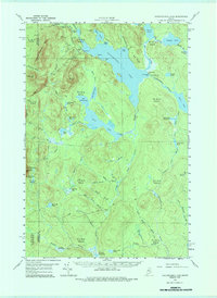
1958 Map of Caucomgomoc Lake
USGS Topo · Published 1987About this map
Caucomgomoc Lake dominates this mid-century landscape in Northern Maine, a region defined by extensive timberlands and complex waterways. The 1958 field survey reveals a wilderness managed for logging and recreation, connected by a network of private roads rather than public highways. Industrial and hydraulic control is evident at Caucomgomoc Dam and Loon Lake Dam, while the presence of Gravel Pits suggests the infrastructure maintenance required for remote forest operations. Topographical landmarks like Caucomgomoc Mtn and Telephone Hill rise above a dense collection of water bodies, including Shallow Lake and Big Hurd Pond. The map also captures the peculiar nomenclature of the area's moving waters, such as the rapid section of Caucomgomoc Stream known as The Horserace. This document serves as a detailed record of the West East Lesser Section (WELS) townships before modern industrial changes altered the backwoods character of the Maine woods.
Find a feature on this map
77 named features on this map. Tap any name to fly to it.
Don’t see what you’re looking for? This feature index may not catch every label — zoom into the map to look around manually.
Map Details
Editions of this 1958 Caucomgomoc Lake Map
4 editions found

Other maps of this area

1954 · Seboomook Lake
USGS Topo · 1:62,500

1954 · Chesuncook
USGS Topo · 1:62,500

1954 · North East Carry
USGS Topo · 1:62,500

1954 · Baker Lake
USGS Topo · 1:62,500

1954 · Caucomgomoc Lake
USGS Topo · 1:62,500

1954 · Churchill Lake
USGS Topo · 1:62,500

1954 · Allagash Lake
USGS Topo · 1:62,500

1954 · St. John Pond
USGS Topo · 1:62,500

1954 · Grant Farm
USGS Topo · 1:62,500

1954 · Presque Isle
USGS Topo · 1:250,000