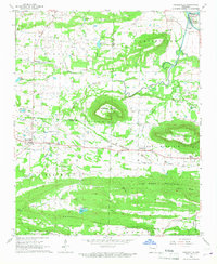
1966 Map of Caulksville
USGS Topo · Published 1967About this map
Caulksville and Carbon City sit at the center of this 1960s landscape, where the Missouri Pacific railroad cuts through the heart of the Arkansas coal country. The map documents an era of industrial activity, marked by numerous strip mines and mine dumps scattered between Horseshoe Mountain and Short Mountain. This concentration of extraction facilities suggests a busy regional economy built on the coal seams of the Ozark National Forest foothills. Away from the mines, the landscape is defined by communal landmarks like Little Flock Ch, Shaver Ch, and St Anthony Ch, alongside several family cemeteries such as McVay Cem and Carpenter Cem. To the north, the Arkansas River winds past Okane Island and Hogan recreation area, providing a sharp contrast to the industrial and agricultural activity of the Sixmile Creek valley.
Find a feature on this map
51 named features on this map. Tap any name to fly to it.
Don’t see what you’re looking for? This feature index may not catch every label — zoom into the map to look around manually.
Map Details
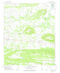
Editions of this 1966 Caulksville Map
2 editions found
Other maps of this area

1879 · Mountain Home
USGS Topo · 1:62,500

1887 · Magazine Mountain #1
USGS Topo · 1:62,500

1887 · Magazine Mountain #4
USGS Topo · 1:62,500

1887 · Magazine Mountain #2
USGS Topo · 1:62,500

1887 · Magazine Mountain #3
USGS Topo · 1:62,500

1887 · Magazine Mountain
USGS Topo · 1:62,500

1890 · Magazine Mountain
USGS Topo · 1:125,000

1934 · Booneville
USGS Topo · 1:48,000

1939 · Booneville
USGS Topo · 1:62,500

1956 · Russellville
USGS Topo · 1:250,000