
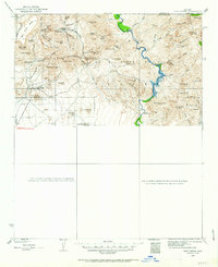
1930 Map of Cave Creek
USGS Topo · Published 1959About this map
Cavecreek and its surrounding ranchlands are captured here during a transitional era for central Arizona, as ranching and early tourism began to define the region. The landscape is dotted with established family holdings such as the Cartwright Ranch and Sears Kay Ranch, alongside the Spur Cross Dude Ranch, signaling the rise of the guest ranch industry. To the west, the Mormon Girl Mine sits near the base of Black Mtn, serving as a reminder of the area's mineral prospects. Much of the eastern portion of the sheet is dominated by the Tonto National Forest, where the Verde River flows past the J M Ranch and the USGS Gaging Sta. This geography highlights the essential relationship between the arid canyonlands and the water sources that sustained both the high-country ranger stations, like Ashdale Ranger Sta, and the valley's developing homesteads.
Find a feature on this map
75 named features on this map. Tap any name to fly to it.
Don’t see what you’re looking for? This feature index may not catch every label — zoom into the map to look around manually.
Map Details
Editions of this 1930 Cave Creek Map
2 editions found
Other maps of this area

1887 · Verde
USGS Topo · 1:250,000

1887 · Prescott
USGS Topo · 1:250,000

1892 · Verde
USGS Topo · 1:250,000

1892 · Prescott
USGS Topo · 1:250,000

1900 · Florence
USGS Topo · 1:125,000

1902 · Florence
USGS Topo · 1:125,000

1903 · Bradshaw Mountains
USGS Topo · 1:125,000

1904 · Camelback
USGS Topo · 1:62,500

1904 · Desert Well
USGS Topo · 1:62,500

1904 · Ft. McDowell
USGS Topo · 1:62,500