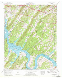
1968 Map of Cave Creek
USGS Topo · Published 1972About this map
Kingston sits at the western edge of a landscape defined by the winding waters of Watts Bar Lake and the Tennessee River. This 1960s survey captures the area at a point of transition between established ridge-top communities and the managed waters of the Tennessee Valley Authority. Parallel ridges including Gallaher Ridge, Dug Ridge, and Copper Ridge structure the terrain, creating narrow valleys where small settlements like New Midway and Bradbury are located.
Find a feature on this map
79 named features on this map. Tap any name to fly to it.
Don’t see what you’re looking for? This feature index may not catch every label — zoom into the map to look around manually.
Map Details
Editions of this 1968 Cave Creek Map
3 editions found
Other maps of this area

1887 · Kingston
USGS Topo · 1:125,000

1891 · Kingston
USGS Topo · 1:125,000

1893 · Kingston
USGS Topo · 1:125,000

1895 · Loudon
USGS Topo · 1:125,000

1935 · Lenoir City
USGS Topo · 1:24,000

1935 · Elverton
USGS Topo · 1:24,000

1935 · Bethel Valley
USGS Topo · 1:24,000

1935 · Harriman
USGS Topo · 1:24,000

1935 · Philadelphia
USGS Topo · 1:24,000

1936 · Cave Creek
USGS Topo · 1:24,000