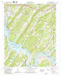
1968 Map of Cave Creek
USGS Topo · Published 1979About this map
The Tennessee River snakes through a landscape of parallel ridges in this late-1960s revision of Roane and Loudon counties. Dominated by the waters of Watts Bar Lake, the terrain is defined by the steep elevation of Chestnut Ridge and Copper Ridge, which channel the river into dramatic bends such as Matlock Bend. While Kingston appears in the northwest corner, much of the area remains rural, marked by small settlements like Bradbury and Dogwood. The map is particularly rich for genealogists, identifying numerous family burial grounds including Neergaard Cem, Zwicker Cem, and Bisplinghoff Cem. The emergence of recreational interests is evident in the Lakeside Golf Course and Long Island Dock, contrasting with the wilder stretches of the Watts Bar Wildlife Management Area and the several islands, such as Huffine Island, that break the lake's surface.
Find a feature on this map
77 named features on this map. Tap any name to fly to it.
Don’t see what you’re looking for? This feature index may not catch every label — zoom into the map to look around manually.
Map Details
Editions of this 1968 Cave Creek Map
3 editions found
Other maps of this area

1887 · Kingston
USGS Topo · 1:125,000

1891 · Kingston
USGS Topo · 1:125,000

1893 · Kingston
USGS Topo · 1:125,000

1895 · Loudon
USGS Topo · 1:125,000

1935 · Lenoir City
USGS Topo · 1:24,000

1935 · Elverton
USGS Topo · 1:24,000

1935 · Bethel Valley
USGS Topo · 1:24,000

1935 · Harriman
USGS Topo · 1:24,000

1935 · Philadelphia
USGS Topo · 1:24,000

1936 · Cave Creek
USGS Topo · 1:24,000