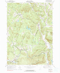
1972 Map of Cavendish
USGS Topo · Published 1991About this map
The Black River carves a significant path through this part of Windsor County, defining the industrial and social development of settlements like Cavendish and Whitesville. The river's power is harnessed at the Powerplant near the dramatic Cavendish Gorge, a local landmark that highlights the area's steep vertical relief. This early 1970s landscape is dotted with small hilltop hamlets and valley villages, including Felchville, South Reading, and Hammondsville, many connected by historic routes like the South Reading Road and Town Farm Road.
Find a feature on this map
54 named features on this map. Tap any name to fly to it.
Don’t see what you’re looking for? This feature index may not catch every label — zoom into the map to look around manually.
Map Details
Editions of this 1972 Cavendish Map
3 editions found
Other maps of this area

1906 · Hanover
USGS Topo · 1:62,500

1908 · Hanover
USGS Topo · 1:62,500

1911 · Woodstock
USGS Topo · 1:62,500

1913 · Woodstock
USGS Topo · 1:62,500

1926 · Claremont
USGS Topo · 1:62,500

1928 · Ludlow
USGS Topo · 1:48,000

1929 · Claremont
USGS Topo · 1:62,500

1929 · Ludlow
USGS Topo · 1:62,500

1932 · Ludlow
USGS Topo · 1:62,500

1943 · Woodstock
USGS Topo · 1:62,500