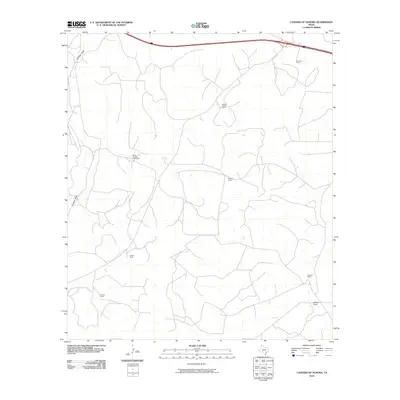
2010 Map of Caverns of Sonora
USGS Topo · Published 2010About this map
Valliant Ranch and several other family-owned estates anchor this 2010 topographic record of the Edwards Plateau region in Sutton County. The landscape is defined by its ranching history and the ephemeral watercourses that carve through the limestone terrain, most notably Granger Draw and Halbert Draw. This map documents a sprawling network of ranch roads and remote homesteads, including Simmons Ranch and the uniquely named Mayer Number Nine Ranch. The proximity to the caverns is marked by the presence of Interstate 10 crossing the northern section, connecting these isolated properties to the wider world. Geographers and local historians can use this survey to understand the spatial distribution of West Texas ranching operations, from the Locklin Ranch to the Ingham Ranch, at the start of the 21st century.
Find a feature on this map
11 named features on this map. Tap any name to fly to it.
Don’t see what you’re looking for? This feature index may not catch every label — zoom into the map to look around manually.
Map Details
Editions of this 2010 Caverns of Sonora Map
This is the sole edition of this map. No revisions or reprints were ever made.
Other maps of this area

1954 · Sonora
USGS Topo · 1:250,000

1958 · Sonora
USGS Topo · 1:250,000

1964 · Sonora
USGS Topo · 1:24,000

1964 · Sonora NW
USGS Topo · 1:24,000

1967 · Nolen Draw
USGS Topo · 1:24,000

1967 · Savell Ranch
USGS Topo · 1:24,000

1967 · Dunbar Draw NW
USGS Topo · 1:24,000

1967 · Shafter Draw
USGS Topo · 1:24,000

1967 · Hudspeth Draw
USGS Topo · 1:24,000

1967 · Caverns Of Sonora
USGS Topo · 1:24,000