
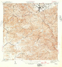
1946 Map of Cayey
USGS Topo · Published 1946About this map
The mountain town of Cayey serves as a focal point for this 1940s survey of the Cordillera Central in Puerto Rico. The landscape is defined by its agricultural heritage, prominently featuring several large estates including Hacienda Clavell, Hacienda Húcar, and Hacienda Julia. These haciendas, along with smaller settlements like Buena Vista and La Plena, suggest a rural economy centered on the high valleys and steep slopes of the interior. The historic Carretera Central winds through the northern portion of the quadrangle, reflecting the vital transport link across the island's spine.
Find a feature on this map
49 named features on this map. Tap any name to fly to it.
Don’t see what you’re looking for? This feature index may not catch every label — zoom into the map to look around manually.
Map Details
Editions of this 1946 Cayey Map
2 editions found
Other maps of this area

1945 · Central Aguirre
USGS Topo · 1:30,000

1945 · Salinas
USGS Topo · 1:30,000

1946 · Patillas
USGS Topo · 1:30,000

1946 · Coamo
USGS Topo · 1:30,000

1946 · Barranquitas
USGS Topo · 1:30,000

1946 · Comerio
USGS Topo · 1:30,000

1946 · Guayama
USGS Topo · 1:30,000

1946 · Caguas
USGS Topo · 1:30,000

1947 · Cayey NO
USGS Topo · 1:10,000

1947 · Patillas SO
USGS Topo · 1:10,000
Featured Places
- Cayey
- Alturas de Cantera, Cayey
- Sector Rústico Rivera, Cayey
- Sector La Sierra, Aibonito
- Sector Ramón Malavé, Cayey