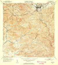
1953 Map of Cayey
USGS Topo · Published 1953About this map
Cayey serves as the focal point of this mid-century topographical survey, situated at the crossroads of the Carretera Central and the Desvio. The landscape transitions from the urban core of Pueblo Norte and Pueblo Sur to the high ridges of the Cordillera Central and the Sierra de Cayey. Throughout the valley and slopes, agricultural legacies are evident in the placement of several large estates, including Hacienda Clavell, Hacienda Hucar, and Hacienda Julia. These rural nodes are connected by a network of quebradas and rivers, such as the Rio de la Plata and Rio Jajome, which define the municipal boundaries. Local social centers are marked by landmarks like the Escuela Rexford G Tugwell and religious sites including the Iglesia Sagrado Corazon and Capilla de Santa Marta. The presence of the U S Military Res and the Casa del Gobernador highlights the strategic and administrative importance of this mountain region in the early 1950s.
Find a feature on this map
81 named features on this map. Tap any name to fly to it.
Don’t see what you’re looking for? This feature index may not catch every label — zoom into the map to look around manually.
Map Details
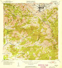
Editions of this 1953 Cayey Map
2 editions found
Other maps of this area

1945 · Central Aguirre
USGS Topo · 1:30,000

1945 · Salinas
USGS Topo · 1:30,000

1946 · Patillas
USGS Topo · 1:30,000

1946 · Coamo
USGS Topo · 1:30,000

1946 · Barranquitas
USGS Topo · 1:30,000

1946 · Cayey
USGS Topo · 1:30,000

1946 · Comerio
USGS Topo · 1:30,000

1946 · Guayama
USGS Topo · 1:30,000

1946 · Caguas
USGS Topo · 1:30,000

1947 · Cayey NO
USGS Topo · 1:10,000
Featured Places
- Cayey
- Alturas de Cantera, Cayey
- Sector Rústico Rivera, Cayey
- Sector La Sierra, Aibonito
- Sector Ramón Malavé, Cayey