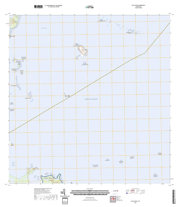
2024 Map of Cayo Icacos
USGS Topo · Published 2024About this map
Isleta Marina stands as a primary point of human activity in this maritime landscape off the coast of Fajardo. The topography is dominated by an archipelago of small islands and coral reefs, including the large Pineros Island, also known as Isla Piñeros, and the leisure-oriented Isla Palominos. The maritime environment is intricate, featuring extensive reef systems like Arrecife Roncador and Arrecife Mata Caballos that shape the navigation of Rada Fajardo. This survey illustrates the relationship between the mainland headlands, such as Cabo San Juan, and the protective barrier islands that define the Sonda de Vieques. Further out, isolated features like Cayo Diablo and La Blanquilla indicate the extent of the shelf before deeper waters. The map effectively documents the transition from coastal points like Punta Figueras to the shoals and keys that have long influenced the local fishing and maritime economy.
Find a feature on this map
31 named features on this map. Tap any name to fly to it.
Don’t see what you’re looking for? This feature index may not catch every label — zoom into the map to look around manually.
Map Details
Editions of this 2024 Cayo Icacos Map
This is the sole edition of this map. No revisions or reprints were ever made.
Other maps of this area

1945 · Cayo Icacos
USGS Topo · 1:30,000

1946 · Punta Puerca
USGS Topo · 1:30,000

1946 · Naguabo
USGS Topo · 1:30,000

1946 · Fajardo
USGS Topo · 1:30,000

1947 · Naguabo NE
USGS Topo · 1:10,000

1947 · Fajardo NE
USGS Topo · 1:10,000
1952 · Cayo Icacos
USGS Topo · 1:30,000

1952 · Punta Puerca
USGS Topo · 1:30,000
1952 · Naguabo
USGS Topo · 1:30,000
1952 · Fajardo
USGS Topo · 1:30,000