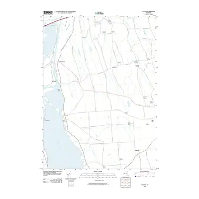
2010 Map of Cayuga
USGS Topo · Published 2010About this map
Cayuga Lake and the Seneca River anchor this landscape at the northern tip of the Finger Lakes region. The water system is defined by the historic Cayuga and Seneca Canal, including the notable Mud Lock and Lockview Marina north of the village of Cayuga. This survey provides a look at the area's rural character, where large agricultural operations like O'Hara Dairy Farms and the Cranebrook Tree Farm sit among a high density of small family and community burial grounds. Genealogists will find a wealth of records in the numerous cemeteries scattered across the township, from the Lakeview Cemetery on the lakefront to the Maycumber Family Cemetery and Smith Cemetery further inland. The northern reaches are dominated by the Montezuma National Wildlife Reserve, which encompasses the Montezuma Marsh and Kipp Island near the Clyde River.
Find a feature on this map
77 named features on this map. Tap any name to fly to it.
Don’t see what you’re looking for? This feature index may not catch every label — zoom into the map to look around manually.
Map Details
Editions of this 2010 Cayuga Map
This is the sole edition of this map. No revisions or reprints were ever made.
Other maps of this area

1899 · Auburn
USGS Topo · 1:62,500

1902 · Geneva
USGS Topo · 1:62,500

1902 · Clyde
USGS Topo · 1:62,500

1902 · Weedsport
USGS Topo · 1:62,500

1902 · Auburn
USGS Topo · 1:62,500

1943 · Montezuma
USGS Topo · 1:31,680

1943 · Cayuga
USGS Topo · 1:31,680
1943 · Romulus
USGS Topo · 1:31,680
1943 · Scipio
USGS Topo · 1:31,680

1943 · Savannah
USGS Topo · 1:31,680