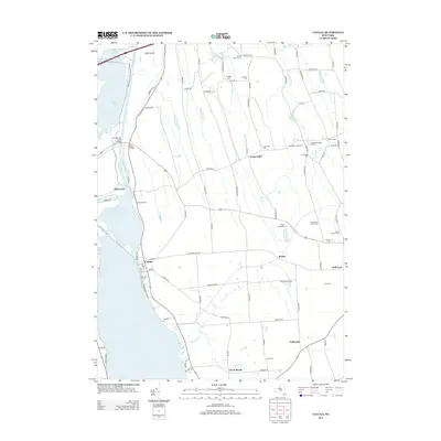
2013 Map of Cayuga
USGS Topo · Published 2013About this map
The eastern shores of Cayuga Lake and the marshlands of the Montezuma National Wildlife Refuge define the landscape of this western Cayuga County corridor. Along the lakefront, the village of Cayuga sits near the intersection of several local routes, while the historic Mud Lock and Lockview Marina mark the connection to the regional canal system. This modern survey shows a rural landscape where agriculture remains central, evidenced by O'Hara Dairy Farms and the Cranebrook Tree Farm. Numerous family burial grounds and small plots, such as the Maycumber Family Cem and Cowan Farnham Cem, are scattered across the terrain, offering significant value for genealogical research. Further inland, smaller crossroads like Fosterville and Relius anchor the farming communities between Crane Brook and Yawger Cr.
Find a feature on this map
93 named features on this map. Tap any name to fly to it.
Don’t see what you’re looking for? This feature index may not catch every label — zoom into the map to look around manually.
Map Details
Editions of this 2013 Cayuga Map
This is the sole edition of this map. No revisions or reprints were ever made.
Other maps of this area

1899 · Auburn
USGS Topo · 1:62,500

1902 · Geneva
USGS Topo · 1:62,500

1902 · Clyde
USGS Topo · 1:62,500

1902 · Weedsport
USGS Topo · 1:62,500

1902 · Auburn
USGS Topo · 1:62,500

1943 · Montezuma
USGS Topo · 1:31,680

1943 · Cayuga
USGS Topo · 1:31,680
1943 · Romulus
USGS Topo · 1:31,680
1943 · Scipio
USGS Topo · 1:31,680

1943 · Savannah
USGS Topo · 1:31,680