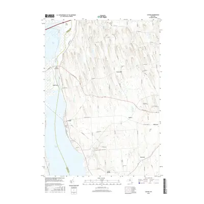
2016 Map of Cayuga
USGS Topo · Published 2016About this map
Montezuma Marsh and the surrounding wetland corridor dominate the northwestern reaches of this map, illustrating the complex hydrology where the Clyde River and Seneca River converge. This 2016 survey captures a landscape defined by its glacial history and water management, with the Cay and Sen Canal Bridge and Mud Lock serving as physical markers of the region's historic transportation infrastructure. The village of Cayuga sits on the northeast shore of Cayuga Lake, while the upland drumlin fields to the east are dotted with small agricultural hamlets such as Fosterville and Relius. Genealogists will find a wealth of family history in the numerous small burial grounds scattered across the terrain, including the Maycumber Family Cem and the Cowan-Farnham Cem, which remain tucked away on local roads like Clark Street Rd.
Find a feature on this map
89 named features on this map. Tap any name to fly to it.
Don’t see what you’re looking for? This feature index may not catch every label — zoom into the map to look around manually.
Map Details
Editions of this 2016 Cayuga Map
This is the sole edition of this map. No revisions or reprints were ever made.
Other maps of this area

1899 · Auburn
USGS Topo · 1:62,500

1902 · Geneva
USGS Topo · 1:62,500

1902 · Clyde
USGS Topo · 1:62,500

1902 · Weedsport
USGS Topo · 1:62,500

1902 · Auburn
USGS Topo · 1:62,500

1943 · Montezuma
USGS Topo · 1:31,680

1943 · Cayuga
USGS Topo · 1:31,680
1943 · Romulus
USGS Topo · 1:31,680
1943 · Scipio
USGS Topo · 1:31,680

1943 · Savannah
USGS Topo · 1:31,680