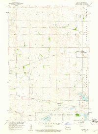
1958 Map of Cayuga
USGS Topo · Published 1960About this map
Great Northern rail lines and the Minneapolis St Paul and Sault Ste Marie corridor define the early infrastructure of this Sargent County landscape. The settlements of Cayuga and Rutland serve as the primary hubs, surrounded by the townships of Shuman, Herman, Kingston, and Ransom. The southern portion of the map is dominated by the Tewaukon National Wildlife Refuge and the Sisseton Indian Reservation Boundary, indicating a landscape transitioning from agricultural grid to protected wetlands and tribal lands. Local history and genealogy are anchored by landmarks such as Nordland Cem and Rutland Sch No 2, while the path of the Wild Rice River and Clouds Lake illustrate the natural drainage patterns that shaped regional development. An Old Railroad Grade suggests earlier transportation routes that once connected these prairie communities.
Find a feature on this map
15 named features on this map. Tap any name to fly to it.
Don’t see what you’re looking for? This feature index may not catch every label — zoom into the map to look around manually.
Map Details
Editions of this 1958 Cayuga Map
This is the sole edition of this map. No revisions or reprints were ever made.
Other maps of this area

1907 · Wyndmere
USGS Topo · 1:125,000

1953 · Milbank
USGS Topo · 1:250,000

1953 · Fargo
USGS Topo · 1:250,000

1956 · Fargo
USGS Topo · 1:250,000

1956 · Havana
USGS Topo · 1:24,000

1958 · Milbank
USGS Topo · 1:250,000

1958 · Marlow
USGS Topo · 1:24,000

1958 · Rutland
USGS Topo · 1:24,000

1958 · Veblen NE
USGS Topo · 1:24,000

1958 · Cayuga NW
USGS Topo · 1:24,000