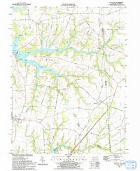
1993 Map of Cecilton
USGS Topo · Published 1993About this map
Sassafras Neck and Middle Neck define the geography of this Maryland-Delaware border region, situated between the tidal waters of the Sassafras River and the branching reaches of Great Bohemia Creek. The settlement of Cecilton serves as a primary crossroads in the southwest, while the village of Warwick sits directly against the Maryland-Delaware state line. Historical landmarks such as the St Francis Xavier Ch and Mt Olivet Ch appear alongside family-named locations like Ginns Corner and Bohemia Mills. The landscape is etched with numerous tidal inlets including Little Bohemia Creek, Manor Creek, and Buckalow Creek, reflecting a coastal plain economy deeply tied to the water. In the northern reaches, the Woodstock Landing Strip and the small community of St Augustine indicate a rural interior transitioning toward the Delaware border.
Find a feature on this map
52 named features on this map. Tap any name to fly to it.
Don’t see what you’re looking for? This feature index may not catch every label — zoom into the map to look around manually.
Map Details
Editions of this 1993 Cecilton Map
This is the sole edition of this map. No revisions or reprints were ever made.
Other maps of this area

1898 · Elkton
USGS Topo · 1:62,500

1899 · Dover
USGS Topo · 1:125,000

1900 · Elkton
USGS Topo · 1:62,500

1900 · Cecilton
USGS Topo · 1:62,500

1904 · Wilmington
USGS Topo · 1:62,500

1906 · Dover
USGS Topo · 1:125,000

1906 · Wilmington
USGS Topo · 1:62,500

1917 · Elkton
USGS Topo · 1:62,500

1919 · Wilmington
USGS Topo · 1:62,500

1920 · Dover
USGS Topo · 1:125,000