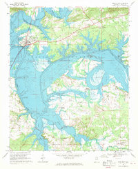
1967 Map of Cedar Bluff
USGS Topo · Published 1969About this map
Cornwall Furnace stands as a landmark of the early industrial landscape north of the Chattooga River in this Cherokee County survey. The town of Cedar Bluff serves as the local hub, featuring an Athletic Field, Filtration Plant, and the County Training Sch. The central geography is dominated by the sprawling Weiss Reservoir, which reached its normal pool elevation in the years preceding this field check. The reservoir has transformed the confluence of the Coosa River and the Chattooga, creating a series of peninsulas and inlets where several rural communities remain established. Away from the water, the map reveals a traditional network of agricultural intersections, including Newberry Crossroads, Howells Crossroads, and Tucker Crossroads. Genealogists will find numerous small centers of community life, from the St Marks Ch and Caledonia Ch to the Ebenezer Cem, alongside evidence of older transit routes like the Old Railroad Grade.
Find a feature on this map
32 named features on this map. Tap any name to fly to it.
Don’t see what you’re looking for? This feature index may not catch every label — zoom into the map to look around manually.
Map Details
Editions of this 1967 Cedar Bluff Map
3 editions found
Other maps of this area

1886 · Rome
USGS Topo · 1:125,000

1893 · Fort Payne
USGS Topo · 1:125,000

1898 · Rome
USGS Topo · 1:125,000

1898 · Fort Payne
USGS Topo · 1:125,000

1899 · Rome
USGS Topo · 1:125,000

1900 · Fort Payne
USGS Topo · 1:125,000

1904 · Rome
USGS Topo · 1:125,000

1955 · Rome
USGS Topo · 1:250,000

1958 · Rome
USGS Topo · 1:250,000

1961 · Rome
USGS Topo · 1:250,000