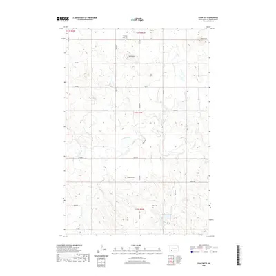
2020 Map of Cedar Butte
USGS Topo · Published 2020About this map
Spring Butte and the namesake Cedar Butte dominate this section of the North Dakota plains in Adams County. This landscape is defined by its intermittent drainage patterns and isolated high points, where Cedar Creek and its smaller tributaries like Duck Creek carve through the prairie. The region's history is anchored at the Union Cem / Spring Butte Cem, a primary genealogical landmark situated in the northern reaches of the quadrangle. A structured grid of section-line roads, including 9th Ave NE and Watros Rd, provides access across the townships. This 2020 edition reveals the persistence of early land divisions and the sparse, rural nature of the high plains, where landmarks such as Robbers Butte served as essential navigational points for generations of ranchers and travelers.
Find a feature on this map
27 named features on this map. Tap any name to fly to it.
Don’t see what you’re looking for? This feature index may not catch every label — zoom into the map to look around manually.
Map Details
Editions of this 2020 Cedar Butte Map
This is the sole edition of this map. No revisions or reprints were ever made.
Other maps of this area

1953 · Dickinson
USGS Topo · 1:250,000

1954 · Lemmon
USGS Topo · 1:250,000

1957 · Dickinson
USGS Topo · 1:250,000

1957 · Lemmon
USGS Topo · 1:250,000
1974 · Nason Hill
USGS Topo · 1:24,000
1974 · Plum Butte NE
USGS Topo · 1:24,000

1974 · Cedar Butte
USGS Topo · 1:24,000

1974 · Long Butte
USGS Topo · 1:24,000

1974 · White Butte
USGS Topo · 1:24,000

1974 · Lemmon
USGS Topo · 1:24,000