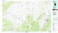
1982 Map of Cedar City
USGS Topo · Published 1982About this map
Cedar City serves as the eastern anchor of this 1982 survey, where the Hurricane Cliffs meet the broad plains. The landscape is defined by the expanse of the Escalante Desert and Escalante Valley, where a network of straight-line roads and the Union Pacific railroad connect isolated desert settlements like Beryl and Modena. This rail line follows a historical corridor through the desert, linking these remote outposts to the more populous foothills.
Find a feature on this map
83 named features on this map. Tap any name to fly to it.
Don’t see what you’re looking for? This feature index may not catch every label — zoom into the map to look around manually.
Map Details
Editions of this 1982 Cedar City Map
This is the sole edition of this map. No revisions or reprints were ever made.
Other maps of this area

1885 · St. George
USGS Topo · 1:250,000

1885 · Beaver
USGS Topo · 1:250,000

1885 · Pioche
USGS Topo · 1:250,000

1886 · Kanab
USGS Topo · 1:250,000

1886 · Pioche
USGS Topo · 1:250,000

1891 · St. George
USGS Topo · 1:250,000
1949 · Cedar City NW
USGS Topo · 1:24,000

1950 · Cedar City NW
USGS Topo · 1:24,000
1950 · Kanarraville
USGS Topo · 1:24,000
1950 · Antelope Peak
USGS Topo · 1:24,000