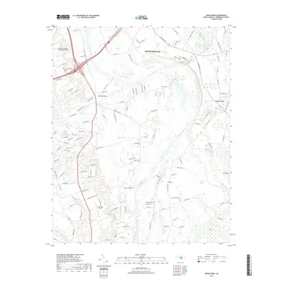
2019 Map of Cedar Creek
USGS Topo · Published 2019About this map
The Cape Fear River carves a winding path through this landscape south of Fayetteville, defining the region's low-lying hydrology and settlement patterns. The map captures the meeting of several significant wetlands and drainage systems, including the Murphy Swamp, Big Alligator Swamp, and the Hair Canal, which speak to the complex water management required in this coastal plain environment. Near the settlement of Grays Creek, the local infrastructure is anchored by the Grays Creek Airport and the historic Evans Cem, offering valuable points of reference for genealogists tracing family roots in the area. The eastern portion of the sheet is dominated by the namesake community of Cedar Creek, where the terrain transitions into the dense marshlands of Smiths Mill Bay and Dudley Pond. Aviation and transit take center stage on the western edge with the Fayetteville Regional Airport/Grannis Field serving as a major regional landmark.
Find a feature on this map
123 named features on this map. Tap any name to fly to it.
Don’t see what you’re looking for? This feature index may not catch every label — zoom into the map to look around manually.
Map Details
Editions of this 2019 Cedar Creek Map
This is the sole edition of this map. No revisions or reprints were ever made.
Other maps of this area

1948 · Fayetteville
USGS Topo · 1:62,500

1949 · Vander
USGS Topo · 1:24,000

1950 · Fayetteville
USGS Topo · 1:24,000

1953 · Florence
USGS Topo · 1:250,000

1953 · Raleigh
USGS Topo · 1:250,000

1954 · Florence
USGS Topo · 1:250,000

1954 · Raleigh
USGS Topo · 1:250,000

1957 · Vander
USGS Topo · 1:24,000
1957 · Fayetteville
USGS Topo · 1:24,000

1957 · Fayetteville
USGS Topo · 1:62,500