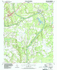
1986 Map of Cedar Creek
USGS Topo · Published 1987About this map
The Cape Fear River winds through this region south of Fayetteville, defining a landscape of wetlands and extractive industry in the mid-1980s. Extensive Sandpit and Gravel Pits operations line the riverbanks and the corridor of the CSX railroad, while the northwestern corner is occupied by the Municipal Airport Grannis Field. The map documents a well-established rural social fabric, evidenced by a high density of small congregations and community centers, including Mt Calvary Ch, Bethlehem Ch, and the Grays Creek Community Ctr.
Find a feature on this map
52 named features on this map. Tap any name to fly to it.
Don’t see what you’re looking for? This feature index may not catch every label — zoom into the map to look around manually.
Map Details
Editions of this 1986 Cedar Creek Map
This is the sole edition of this map. No revisions or reprints were ever made.
Other maps of this area

1948 · Fayetteville
USGS Topo · 1:62,500

1949 · Vander
USGS Topo · 1:24,000

1950 · Fayetteville
USGS Topo · 1:24,000

1953 · Florence
USGS Topo · 1:250,000

1953 · Raleigh
USGS Topo · 1:250,000

1954 · Florence
USGS Topo · 1:250,000

1954 · Raleigh
USGS Topo · 1:250,000

1957 · Vander
USGS Topo · 1:24,000
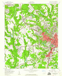
1957 · Fayetteville
USGS Topo · 1:24,000

1957 · Fayetteville
USGS Topo · 1:62,500