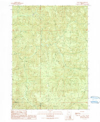
1990 Map of Cedar Creek
USGS Topo · Published 1990About this map
The Williams River carves through this drainage system in western Oregon, defining a landscape dominated by timber-country topography and complex water networks at the border of Douglas and Coos Counties. This 1990 provisional survey documents a period of limited accessibility, where transit through the steep terrain is largely restricted to 4wd tracks that follow ridgelines and creek beds. The drainage pattern is exceptionally dense, featuring numerous named tributaries like Gods Thumb Creek, Arrow Creek, and Skip Creek which feed into the larger arterial flows of Cedar Creek and the river. Significant elevation points, such as Green Peak in the northeast, provide a sense of the vertical scale and depth of these coastal range valleys. Local historians and genealogists can use the map to trace specific watershed boundaries and land divisions defined by the section lines and township markers, including Townships 26 and 27 South.
Find a feature on this map
19 named features on this map. Tap any name to fly to it.
Don’t see what you’re looking for? This feature index may not catch every label — zoom into the map to look around manually.
Map Details
Editions of this 1990 Cedar Creek Map
This is the sole edition of this map. No revisions or reprints were ever made.
Other maps of this area

1928 · Sitkum
USGS Topo · 1:125,000

1955 · Camas Valley
USGS Topo · 1:62,500

1955 · Ivers Peak
USGS Topo · 1:62,500

1955 · Sitkum
USGS Topo · 1:62,500

1955 · Tyee
USGS Topo · 1:62,500

1958 · Roseburg
USGS Topo · 1:250,000

1959 · Roseburg
USGS Topo · 1:250,000

1979 · Roseburg
USGS Topo · 1:100,000
1990 · Ivers Peak
USGS Topo · 1:24,000
1990 · Callahan
USGS Topo · 1:24,000