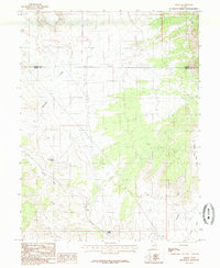
1985 Map of Cedar
USGS Topo · Published 1985About this map
Cedar sits at the heart of this high-desert landscape, captured during a mid-1980s U.S. Geological Survey project. The terrain is defined by a series of drainages and seasonal water sources, including the winding Icelander Creek and Grassy Trail Creek. To the east, the topography transitions into the prominent natural basin of The Cove, where the land begins to drop toward Grassy Wash. This provisional survey shows the area just after the turn of the 1980s, highlighting a network of remote 4wd routes that provided the only access through these arid stretches of the Colorado Plateau. Essential water points for local ranching or travel are documented at Good Water Spring and Coon Spring, while the county boundary between Carbon and Emery counties cuts a straight line through the northern section of the map.
Find a feature on this map
10 named features on this map. Tap any name to fly to it.
Don’t see what you’re looking for? This feature index may not catch every label — zoom into the map to look around manually.
Map Details
Editions of this 1985 Cedar Map
This is the sole edition of this map. No revisions or reprints were ever made.
Other maps of this area

1886 · Price River
USGS Topo · 1:250,000

1896 · Price River
USGS Topo · 1:250,000

1915 · Sunnyside
USGS Topo · 1:62,500

1915 · Wellington
USGS Topo · 1:62,500

1948 · Woodside
USGS Topo · 1:62,500

1949 · Woodside
USGS Topo · 1:62,500

1950 · Woodside
USGS Topo · 1:62,500

1956 · Price
USGS Topo · 1:250,000

1960 · Price
USGS Topo · 1:250,000

1962 · Price
USGS Topo · 1:250,000