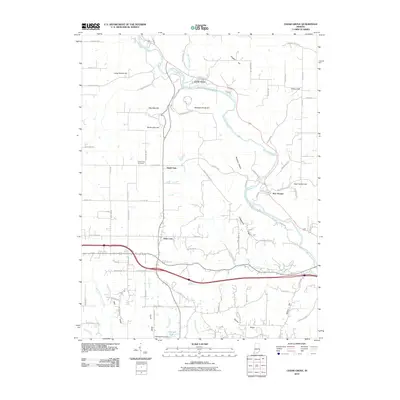
2010 Map of Cedar Grove
USGS Topo · Published 2010About this map
The Whitewater River carves a deep valley through the northeast, where the small settlements of Cedar Grove and New Trenton are established along its banks. This landscape is defined by its significant relief, with numerous named high points such as Gobblers Knob Hill, English Hill, and the curiously named Wee Wee Hill. To the south, the terrain levels slightly into more organized agricultural plots and the community of Saint Leon. The transportation network is a mix of modern thoroughfares and winding rural routes like Old State Hwy 1 and Chappelow Ridge Rd. Local history is anchored by sites like the South Gate Cemetery near the settlement of South Gate. The map also traces various waterways feeding into the larger drainage systems, including Slab Camp Creek, Ennis Creek, and East Fork Tanners Creek.
Find a feature on this map
76 named features on this map. Tap any name to fly to it.
Don’t see what you’re looking for? This feature index may not catch every label — zoom into the map to look around manually.
Map Details
Editions of this 2010 Cedar Grove Map
This is the sole edition of this map. No revisions or reprints were ever made.
Other maps of this area

1915 · Lawrenceburg
USGS Topo · 1:48,000

1915 · Harrison
USGS Topo · 1:48,000

1928 · Lawrenceburg
USGS Topo · 1:62,500

1932 · Lawrenceburg
USGS Topo · 1:62,500

1943 · Hooven
USGS Topo · 1:24,000

1943 · Guilford
USGS Topo · 1:24,000

1953 · Guilford
USGS Topo · 1:24,000

1953 · Cincinnati
USGS Topo · 1:250,000
1954 · Hooven
USGS Topo · 1:24,000

1955 · Harrison
USGS Topo · 1:24,000