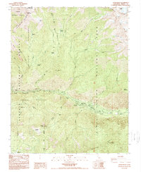
1988 Map of Cedar Grove
USGS Topo · Published 1988About this map
Cedar Grove serves as the focal point of activity on this 1980s survey, situated along the South Fork Kings River within Kings Canyon National Park. The map documents a dense concentration of recreational infrastructure, including the Sheep Creek Campground, Sentinel Campground, Canyon View Campground, and Moraine Campground. This period of park management is marked by the presence of a Helliport and Radio Towers near Lookout Peak, reflecting the logistical needs of wilderness oversight in the High Sierra.
Find a feature on this map
44 named features on this map. Tap any name to fly to it.
Don’t see what you’re looking for? This feature index may not catch every label — zoom into the map to look around manually.
Map Details
Editions of this 1988 Cedar Grove Map
This is the sole edition of this map. No revisions or reprints were ever made.
Other maps of this area

1903 · Tehipite
USGS Topo · 1:125,000

1905 · Tehipite
USGS Topo · 1:125,000

1948 · Fresno
USGS Topo · 1:250,000

1952 · Tehipite Dome
USGS Topo · 1:62,500

1953 · Marion Peak
USGS Topo · 1:62,500

1955 · Fresno
USGS Topo · 1:250,000

1956 · Fresno
USGS Topo · 1:250,000

1956 · Giant Forest
USGS Topo · 1:62,500
1956 · Triple Divide Peak
USGS Topo · 1:62,500

1958 · Fresno
USGS Topo · 1:250,000