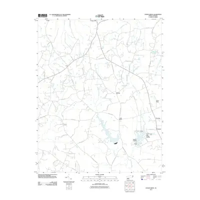
2011 Map of Cedar Grove
USGS Topo · Published 2011About this map
The East Fork Eno River and West Fork Eno River define the rural character of this northern Orange County landscape in the early 21st century. The map centers on the community of Cedar Grove, where agricultural routes like Efland Cedar Grove Rd and Carr Store Rd converge. Further north, the settlement of McDade sits near the upper reaches of Lake Michie, a vital reservoir for the region. Genealogists and local historians can trace family roots through sites such as Harmony Cemetery and Old Eno Cemetery, while modern lakeside developments are evident at Walkers Landing and Just-A-Mere Landing. The terrain is marked by a network of family-named roads, including McCullough Rd and Stewart Farm Rd, illustrating the transition from traditional farmsteads to contemporary residential areas like Green Pines and Deer Run.
Find a feature on this map
67 named features on this map. Tap any name to fly to it.
Don’t see what you’re looking for? This feature index may not catch every label — zoom into the map to look around manually.
Map Details
Editions of this 2011 Cedar Grove Map
This is the sole edition of this map. No revisions or reprints were ever made.
Other maps of this area

1953 · Greensboro
USGS Topo · 1:250,000

1954 · Greensboro
USGS Topo · 1:250,000

1962 · Greensboro
USGS Topo · 1:250,000

1966 · Greensboro
USGS Topo · 1:250,000

1967 · Cedar Grove
USGS Topo · 1:24,000

1968 · Efland
USGS Topo · 1:24,000
1968 · Hillsborough
USGS Topo · 1:24,000

1968 · Caldwell
USGS Topo · 1:24,000

1968 · Ridgeville
USGS Topo · 1:24,000

1968 · Hurdle Mills
USGS Topo · 1:24,000