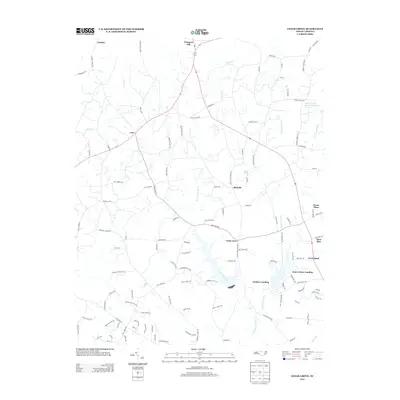
2013 Map of Cedar Grove
USGS Topo · Published 2013About this map
Cedar Grove serves as a central point in this northern Orange County landscape, where the headwaters of several significant drainage systems converge. The area is defined by the winding paths of the E Fork Eno River and W Fork Eno River, which flow southward through a network of rural homesteads and agricultural tracts. Notable water bodies such as Lake Michie and the curiously named Quail Roost Lake Number Two indicate a landscape managed for both utility and recreation. To the north, Prospect Hill and Corbett anchor the upper reaches of the map near S Hyco Cr. The road network, including names like Harmony Church Rd and Wagon Farm Rd, reflects a long history of local land use. The presence of Walkers Landing and Just-A-Mere Landing suggests established access points to the area's waterways, while smaller named settlements like Carr and McDade highlight the dispersed nature of the community.
Find a feature on this map
117 named features on this map. Tap any name to fly to it.
Don’t see what you’re looking for? This feature index may not catch every label — zoom into the map to look around manually.
Map Details
Editions of this 2013 Cedar Grove Map
This is the sole edition of this map. No revisions or reprints were ever made.
Other maps of this area

1953 · Greensboro
USGS Topo · 1:250,000

1954 · Greensboro
USGS Topo · 1:250,000

1962 · Greensboro
USGS Topo · 1:250,000

1966 · Greensboro
USGS Topo · 1:250,000

1967 · Cedar Grove
USGS Topo · 1:24,000

1968 · Efland
USGS Topo · 1:24,000
1968 · Hillsborough
USGS Topo · 1:24,000

1968 · Caldwell
USGS Topo · 1:24,000

1968 · Ridgeville
USGS Topo · 1:24,000

1968 · Hurdle Mills
USGS Topo · 1:24,000