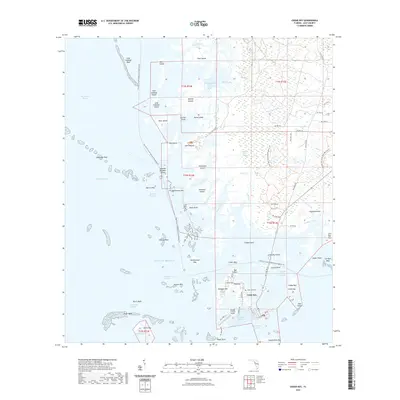
2021 Map of Cedar Key
USGS Topo · Published 2021About this map
Cedar Key serves as the focal point of this coastal survey, highlighting the intricate relationship between the mainland and the offshore archipelago in the Gulf of Mexico. The town's layout on Way Key is detailed alongside vital maritime infrastructure, including the Main Ship Channel, Number Three Channel, and the George T Lewis Airport. This area is characterized by a complex network of salt marshes and tidal creeks such as Goose Creek and Lukens Creek, which transition into the broader waters of Suwannee Sound.
Find a feature on this map
83 named features on this map. Tap any name to fly to it.
Don’t see what you’re looking for? This feature index may not catch every label — zoom into the map to look around manually.
Map Details
Editions of this 2021 Cedar Key Map
This is the sole edition of this map. No revisions or reprints were ever made.
Other maps of this area

1954 · Suwannee
USGS Topo · 1:24,000

1954 · Chiefland SW
USGS Topo · 1:24,000

1954 · East Pass
USGS Topo · 1:24,000

1954 · Gainesville
USGS Topo · 1:250,000

1955 · Seahorse Key
USGS Topo · 1:24,000

1955 · Cedar Key
USGS Topo · 1:24,000

1955 · Sumner
USGS Topo · 1:24,000

1958 · Gainesville
USGS Topo · 1:250,000

1959 · Gainesville
USGS Topo · 1:250,000
1978 · Ocala
USGS Topo · 1:100,000