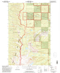
1994 Map of Cedar Lake
USGS Topo · Published 1996About this map
The Mission Range forms a dramatic topographic spine in this 1990s revision, marking the high-elevation divide between various land management jurisdictions. On the western slopes, the Flathead Indian Reservation encompasses high peaks like Moss Peak and includes the Mission Mountains Tribal Wilderness. To the east, the Flathead National Forest and the Swan River State Forest dominate the landscape, characterized by complex drainages such as South Woodward Creek and Fatty Creek. Significant alpine water bodies, including Cedar Lake, Rainbow Lake, and Piper Lake, are tucked into the high glacial cirques of the Mission Mountains Wilderness. The map reveals the intricate network of creek systems—such as Hellroaring Creek and Bisson Creek—that define the western watershed of the reservation.
Find a feature on this map
31 named features on this map. Tap any name to fly to it.
Don’t see what you’re looking for? This feature index may not catch every label — zoom into the map to look around manually.
Map Details
Editions of this 1994 Cedar Lake Map
This is the sole edition of this map. No revisions or reprints were ever made.
Other maps of this area

1920 · Flathead Lake
USGS Topo · 1:125,000

1955 · Choteau
USGS Topo · 1:250,000

1956 · Wallace
USGS Topo · 1:250,000

1957 · Choteau
USGS Topo · 1:250,000

1958 · Choteau
USGS Topo · 1:250,000

1960 · Wallace
USGS Topo · 1:250,000

1962 · Choteau
USGS Topo · 1:250,000

1964 · Bull Island
USGS Topo · 1:24,000

1964 · East Bay
USGS Topo · 1:24,000

1964 · Ronan
USGS Topo · 1:24,000