1891 Map of Cedar Rapids
USGS Topo · Published 1904About this map
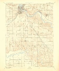
The Cedar River and Iowa River systems dominate the landscape of Linn and Johnson counties in this late-19th-century survey. Cedar Rapids appears as a burgeoning regional hub, its grid expanding at the confluence of several major rail lines including the Chicago and North Western R. R. and the Burlington Cedar Rapids and Northern Railroad. The map captures the era of concentrated rail-side development, highlighting smaller agricultural and post-office junctions like Western, Ely, and Shueyville. Away from the urbanizing core, the terrain is marked by intricate drainage patterns along Prairie Creek and Mill Creek, where the transition from river bottomlands to uplands defined early township boundaries and farming tracts. This reconnaissance work by topographer W.J. Peters documents the foundational infrastructure of eastern Iowa before the automotive era reshaped the countryside.
Find a feature on this map
29 named features on this map. Tap any name to fly to it.
Don’t see what you’re looking for? This feature index may not catch every label — zoom into the map to look around manually.
Map Details
Editions of this 1891 Cedar Rapids Map
2 editions found

Other maps of this area

1887 · Cedar Rapids
USGS Topo · 1:62,500

1888 · Shellsburg
USGS Topo · 1:62,500

1888 · Marion
USGS Topo · 1:62,500

1888 · Amana
USGS Topo · 1:62,500

1889 · Marion
USGS Topo · 1:62,500

1889 · Amana
USGS Topo · 1:62,500

1889 · Shellsburg
USGS Topo · 1:62,500

1890 · Anamosa
USGS Topo · 1:62,500

1891 · Oxford
USGS Topo · 1:62,500

1891 · Mechanicsville
USGS Topo · 1:62,500