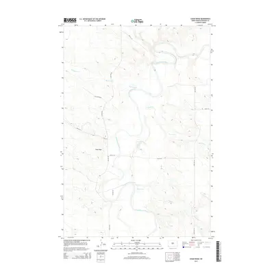
2014 Map of Cedar Ridge
USGS Topo · Published 2014About this map
The Little Missouri River carves a winding path through this corner of Bowman County, creating a complex drainage network defined by Big Gumbo Cr, Sevenmile Cr, and Fivemile Cr. The landscape is dominated by the prominent landform of Cedar Ridge, which serves as a central anchor for the local geography. A sparse grid of rural roads, including 95th St SW and 172nd Ave SW, provides access to this remote prairie terrain. The inclusion of Gas Well Rd points to the energy industry's footprint on the landscape, while labels like Little Beaver Rd reflect more traditional local nomenclature. This 2014 survey captures a moment of modern land use in a region where topography and watercourses still dictate the movement of people and resources.
Find a feature on this map
14 named features on this map. Tap any name to fly to it.
Don’t see what you’re looking for? This feature index may not catch every label — zoom into the map to look around manually.
Map Details
Editions of this 2014 Cedar Ridge Map
This is the sole edition of this map. No revisions or reprints were ever made.
Other maps of this area
1935 · Buffalo
USGS Topo · 1:125,000

1953 · Miles City
USGS Topo · 1:250,000
1953 · Dickinson
USGS Topo · 1:250,000

1954 · Lemmon
USGS Topo · 1:250,000

1954 · Ekalaka
USGS Topo · 1:250,000

1956 · Ekalaka
USGS Topo · 1:250,000
1957 · Dickinson
USGS Topo · 1:250,000

1957 · Lemmon
USGS Topo · 1:250,000

1957 · Miles City
USGS Topo · 1:250,000

1958 · Miles City
USGS Topo · 1:250,000