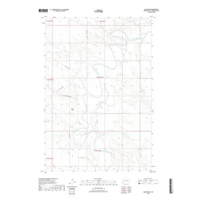
2018 Map of Cedar Ridge
USGS Topo · Published 2018About this map
The Little Missouri River meanders across this corner of North Dakota, cutting through a landscape defined by the prominent landform of Cedar Ridge. By the early 21st century, the region's economy was heavily influenced by energy extraction, as evidenced by a network of specialized routes including Oil Field Rd, Gas Well Rd, and Oil Well Rd. These industrial tracks connect various sites such as BTA Oil Producers, interspersed with conservation land like the Big Gumbo Management Area Rd. Natural drainage patterns are clearly marked by the paths of Big Gumbo Cr, Sevenmile Cr, and Fivemile Cr, which feed into the primary river valley. Long-standing local transit relies on established arteries such as Camp Crook Rd and Little Beaver Rd, providing a framework for the rural infrastructure and resource management that characterizes Bowman County.
Find a feature on this map
24 named features on this map. Tap any name to fly to it.
Don’t see what you’re looking for? This feature index may not catch every label — zoom into the map to look around manually.
Map Details
Editions of this 2018 Cedar Ridge Map
This is the sole edition of this map. No revisions or reprints were ever made.
Other maps of this area
1935 · Buffalo
USGS Topo · 1:125,000

1953 · Miles City
USGS Topo · 1:250,000
1953 · Dickinson
USGS Topo · 1:250,000

1954 · Lemmon
USGS Topo · 1:250,000

1954 · Ekalaka
USGS Topo · 1:250,000

1956 · Ekalaka
USGS Topo · 1:250,000
1957 · Dickinson
USGS Topo · 1:250,000

1957 · Lemmon
USGS Topo · 1:250,000

1957 · Miles City
USGS Topo · 1:250,000

1958 · Miles City
USGS Topo · 1:250,000