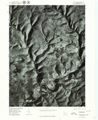
1977 Map of Cedar Run
USGS Topo · Published 1979About this map
The sharp relief of Tioga County is captured in this 1977 orthophotoquad, which uses aerial photography to depict the land in place of traditional contour lines. The settlement of Cedar Run sits at the confluence of its namesake waterway and the winding Pine Creek, which carves a deep valley through the high plateau. This specific format highlights the dense forest cover and the winding corridor of the valley floor, revealing the precise physical relationship between the village and the steep slopes that define the region. For local historians and researchers, the map provides an unmediated view of the ground as it appeared in the late 1970s, showing the exact footprint of buildings and the narrow transit routes dictated by the water.
Find a feature on this map
3 named features on this map. Tap any name to fly to it.
Don’t see what you’re looking for? This feature index may not catch every label — zoom into the map to look around manually.
Map Details
Editions of this 1977 Cedar Run Map
This is the sole edition of this map. No revisions or reprints were ever made.
Other maps of this area

1937 · Waterville
USGS Topo · 1:48,000

1943 · Hyner
USGS Topo · 1:62,500

1943 · Waterville
USGS Topo · 1:62,500

1946 · Tiadaghton
USGS Topo · 1:24,000

1946 · Antrim
USGS Topo · 1:62,500

1946 · Renovo East
USGS Topo · 1:62,500

1946 · Cedar Run
USGS Topo · 1:24,000

1946 · Slate Run
USGS Topo · 1:24,000

1946 · Antrim
USGS Topo · 1:24,000

1946 · Morris
USGS Topo · 1:24,000
Featured Places
- Morris Township, PA
- Brown Township, PA
- Cedar Run, Brown Township
- Elk Township, PA
- Cedar Pines, Brown Township